


Bhojpur is a rural district of the Eastern Development Region, located in the Mid-Hills region in the Koshi Zone. Surrounded by Sankhuwasabha and Dhankuta districts in the east, Khotang in the west, Solukhumbu in the north and Udaipur district in the south, the total area of the district is 1522 sq km. The district occupies 1.02 percent of the total area of Nepal, 5.30 percent of the Eastern Development Region and 15.59 percent of the Koshi Zone.
The town is geographically located in the central hills. The climate here is moderate. The place where this municipality is located is also known as the fort number 4 in medieval Nepal. Bhojpur Bazaar is its administrative center while Dingla Bazaar, Ghoretar, Taksar Bazaar, Chowkidanda, Kulung, Dawa, Changre, Manedanda, Pyauli Bazaar and other prominent places are there. There is a history that the Taksar market was established in medieval Nepal for the coins needed all over Nepal.
Naming of Bhojpur
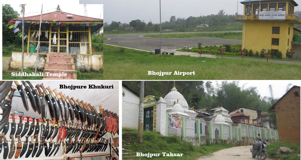
The old name of this district was Siddhapur. It may have been named after Siddhakali, a famous religious site in the district. There is a legend that the name of the place was changed from Siddhapur to “Bhojpur” as Prithvinarayan Shah had a great feast after the conquest of Kirant and the remaining portion of feast (Bhoj) was buried in this place. According to another statement, it is said that Bhojpur was renamed as Bhojpur due to the abundance of Bhojpatra trees in the forests of the high hilly areas of the district.
History
King Mukunda Sen of Palpa conquered the entire territory of Eastern Nepal and made it his kingdom. Later, the state was divided into three states namely Makwanpur, Vijaypur and Chaudandigarhi. In the Chaudandi kingdom was the land from Dudhkoshi to Arun River and in the Terai between Saptakoshi and Kamala rivers. Although its headquarters was at Chaudandi Gadhi, another governing center was established at Hatuwagadhi to facilitate the administration of the hilly region, which now belongs to Raniwas VDC in the southern part of the district.
After the unification of Nepal, the area was administered from Dhankuta in the eastern part of the country, but it was called Majh Kirant. During the Rana period, no. 4 Kirant was an administrative unit in Bhojpur. When the administrative area was divided in 2019 BS, the district was placed in the Everest Zone and has been placed under the Koshi Zone since 2032 BS.
Population and Tribes
The total population of Bhojpur is 17,756 which includes 8945 male and 8791 female population. This district’s social life is marked by more innocence, awareness, and people’s liberation. Since several Kirant castes have lived in this area for over two thousand years, the bulk of Kirant castes remain (37.45%). Apart from this caste, there are Chhetri (20.39%), Tamang (8.67%), Newar (7.66%), Brahmin (5.73%), Magar, Gurung, Damai, Kami, and Sarki.
Major River and Waterfall
Arun River, Sunkoshi River, Pikhuwa, Irkhuwa, Chirkhuwa, Benkhuwa, Yanguwa, Nakhuwa, Kakuwa, Chhintalu, Akhuwa, Wuwa, Juke, Sikdel, Kawa, Nevasukhe, Ghe, Balkhu, Khakuwa, Vahre, Hungrayo, Khesang, Sisuwa, Salpapokhari , Panchkanya, Hanspokhari, Bhabishyavakta Pokhari and Changre Pokhari, Saune Danda Pokhari etc. are some of the popular rivers in this district. Chirkhuwa River Waterfall is the largest and tallest waterfall in the district. The waterfalls of the Helauchha River and the Yangwa River are also attractive waterfalls.
Occupation
Bhojpur is famous for the Khukuri production in the world. It is also one of the leading producers of blackberries, copper bars and oranges in Nepal.
· Khukuri
Khukuri is an English crescent shaped sharp weapon which was made only in Nepal and Bhojpure Khukuri only in Bhojpur district. There is some identity behind how ‘Khukuri’ was born in Bhojpur. In 1872, the Government of Nepal opened a Taksar in Bhojpur called Taksar to cut the metal money needed by all of Nepalese. Not only the work of cutting money but also the local Kirant, especially the Sunuwar, started to manufacture the revered weapon khukuri commercially, which became so famous.
Major Religious and Tourist Areas
This district also looks very beautiful and attractive in terms of tourism. Tyamke and Selme Dando to the west and Chakheva Dand to the north-west seem to be inviting tourists to visit Bhojpur at least once. Similarly, Suntale Bazaar, located in Ward No. 3 of the municipality, offers a panoramic view of the mountains and the deepest Arun Valley in the world. There is a temple of Sikadhakali in the center of the city, which is believed to fulfill one’s aspirations. The temples of Pati Pauwa Devi inside Taksar Bazaar are equally important from a religious point of view.
-by: Kusum Kharel for Land Nepal

